Study group Dinteloord conducts research and collects information and stories about the second world war in and around Dinteloord.
During the Second World War there were many activities in and around Dinteloord, both from the occupiers and from the allies.
During the war, 11 planes crashed on Dinteloord's territory, the details of which are known.
The Volkerak was also a secondary target for the Allied pilots. This meant that if a mission could not be completed or a target was not feasible, the bombs were dropped above the Volkerak. The planes had to drop their bombs or else they could not come back to England, because the ballast then required too much fuel to make the crossing.
The Volkerak was an important waterway to the Randstad for the supply of material and food for the occupiers.
That is why there was a lot of activity in the air around the Volkerak and therefore also above Dinteloord.
Heavy bombing was also carried out by the Allies on the day before the liberation and on the day of the liberation.
Dinteloord has many dead and injured people to mourn through these bombings.
Oprichting monument ter nagedachtenis van de bemanningsleden van de neergestorte vliegtuigen.
We are committed to erecting a monument for the airmen and their crew members who crashed on Dinteloord's territory.
We will take you along all the crashed aircraft on Dinteloord's territory.
Uit rapporten blijkt dat Dinteloord gekend was als front gebied.
Air strikes at Dintelsas refuge
The municipality of Dinteloord and Prinsenland has been severely affected by the effects of the air war. The refuge at Dintelsas, in particular, regularly became the target of air strikes and shelling with guns, the so-called punishment. File no. 3744 from the municipal archive, extensively examines the air attacks on the territory of Dinteloord. In a police monthly report for the period from 15-09-1943 to 14-10-1943, the following was stated: “The supply of beets is made very difficult, because ships in the Volkerak are regularly shot at by aircraft. On 4 October 1943 a ship was shot at, which was located in front of the factory before the coal was unloaded. Hereby 3 people were seriously injured and 2 people were slightly injured ". The mentioned factory was the sugar factory. It can subsequently be said that not one, but two ships, named Fidusia and Dana Adriana, were fired on by four British aircraft on the Mark near the sugar factory. This air attack is therefore not directly relevant in the context of the investigation, because the sugar factory is directly adjacent to Stampersgat;
On 18-10-1943, seven to eight British airborne aircraft carried out attacks on ships in the Volkerak and the refuge. One ship sank, eight ships were more or less seriously damaged. Five people were slightly injured.
On 13-11-1943 British aircraft fired at a ship that was on the Dintelsas. One person was injured as a result of this air raid.
On 30-11-1943 a tugboat in the Volkerak was sunk by allied aircraft (see Appendix VI for a copy of the police report);
Schepen On 29-02-1944 ships were shot at in the port of Dintelsas. One civilian was killed, two others were injured. In regional literature, the following is mentioned about the air raid in question: “English hunters shot the motor tjalk Zeelandia from Cornelis Abel Dane from Sint-Annaland on February 29, 1944 at Dintelsas (Dinteloord). The skipper was fatally hit, his wife remained unharmed. Brother-in-law Adrie Scherpenisse - who was on board too - got off well, although the caps were shot off his clogs. " German reports spoke of a Spitfire attack on the port of Dintelsas at 1:25 pm. A Flak soldier and two civilians were wounded, a navy ship was damaged.
On 25-08-1944 a bomb exploded in the built-up area of Dinteloord.
The other entries with regard to the (air) war are very diverse. The overview below contains a selection of the large amount of data found:
storm In one of the outer dikes of Dinteloord, a large hole was hit by a storm on 08-04-1943. The hole was repaired with the cooperation of the Wehrmacht;
On 04-11-1944 a bombing and aircraft shelling took place on the territory of the municipality of Dinteloord, with the result that several civilians were killed. In connection with this mention, it can be said that as a result of the bombing that took place on 04 and 05-11-1944, the post office of the Marechaussee was completely destroyed;
On 24-02-1945 the acting mayor of Dinteloord reported as follows: “The acting mayor of Dinteloord hereby again warns the residents against the urgency of having to stay in the open air during grenade fire. He also emphasizes the great danger of triggering the anti-aircraft guns. It often happens that blind people or grenade splinters end up in this municipality. During shooting, it is therefore necessary to seek cover. People do not stand in open doors or in front of windows. Restrain your curiosity! ”This quotation shows that the residents were still struggling with falling grenades months after the liberation;
In a letter dated 22-10-1946, the mayor of the municipality of Dinteloord spoke about: "the severely affected municipality of Dinteloord". Among other things the buildings of the sugar factory and buildings on the Havenweg had suffered war damage;
A list of ammunition, projectiles dated 11-12-1944 etc. speaks volumes about the amounts of ammunition that were present in the municipality of Dinteloord after the war: dozens of land mines, mortars, hand grenades and armored fists, boxes with cartridges, grenades, blind people , a few bombs and a "rocket bomb". There were mines on a 16-hectare parcel near Dintelsas, and there was ammunition near the church. In addition, there was damage as a result of shelling. The town hall was damaged by bombs, grenade fire and guns. In the built-up area, the street deck was damaged in almost all streets by bomb hits and / or grenade fire. Two of the three bridges were damaged and four bombs had exploded in the harbor, in combination with the fact that two ships had been blown up, the harbor walls were seriously damaged. Holes were blown in ten places. After a sunken boat barge was lifted in Dintelsas in 1945, it turned out that the vessel contained a "bomb" and 30 boxes of ammunition. There was a lot of ammunition on the dike along the refuge.
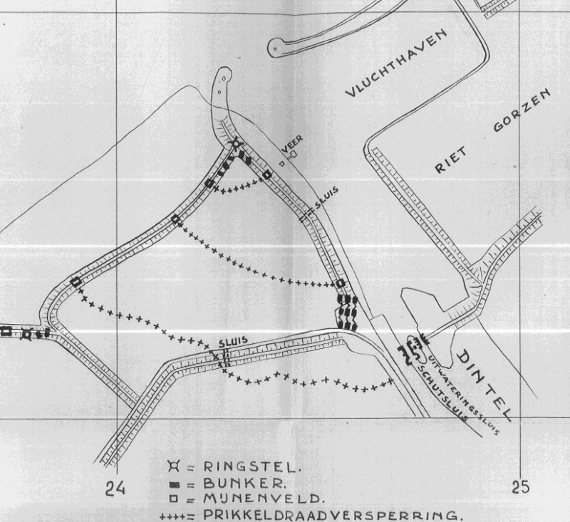

Above: German positions at the refuge in Dintelsas on 23-02-1944
Center: Allied positions along the Volkerak. At the top right is the refuge of Dintelsas visible.
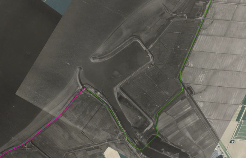
Below, aerial photo of the refuge port on Dintelsas with impact craters clearly visible.
On the basis of War Diaries from The National Archives in London (UK) the following can be established with regard to ground battles:
The municipality of Dinteloord was front area. This is evidenced by the fact that successively different squadrons of the 12th Manitoba Dragoons guarded the front sector of coordinates 590420 to 672451 (northernmost part: port at Dinteloord) in November 1944;
In the War Diary of the 12th Manitoba Dragoons it is stated on 03-12-1944 that three light beacons were placed at the coordinate 6745. This concerns the port at Dinteloord;
On 15-02-1945 a Mustang of the 8th USAAF crashed at the coordinate 618419. This location is in the immediate vicinity of the Kleinedijk, southwest of the research area;
German positions at the refuge at Dintelsas on 23-02-1944
On 16-02-1945 “6 rounds” 105 mm shells fell on coordinates 651439 and 630430. Both locations are relatively close to the research area. This also applies to the "10 rounds" of 105 mm and "25 rounds" 3 inch mortar shells in the area.
On 20-03-1945 the refuge of Dinteloord (coordinate 670451) was bombarded by German artillery. According to the Allied declaration a total of "10 rounds" fell;
On 24-04-1945 about 20 Germans conducted a raid in the Vrouwenpolder, between the coordinates 654440 and 636437. A group of six to eight men, armed with Spandaus, came to the dike and cut the telephone wire. It was a firefight with the men of 62nd Anti Tank Regiment;
Sketch of the Dutch resistance of the port of Dintelsas, with accompanying trenches etc.
On the above-mentioned date, the square 6644 was bombarded with 30 mortars and four gun grenades. The research area, southwest of the refuge of Dinteloord, is within this coordinate. This also applies to the map square 6042, where two grenades landed and the map square 6744, where fifteen mortar shells and nine gun grenades landed on 27-03-1945;
Allied positions along the Volkerak.
Three German mentions from the Second World War also show that the refuge / Dintelsas became the target of German artillery bombardments (origin of mentions: Van Doorn collection):
Entry dated 12/22/1944
Entry dated 26-12-1944
Entry dated 26-12- 1944
Both the Daily Logs of the 2nd Air Force, as well as the Operations Record Books (ORBs) of Squadrons of the Royal Air Force involved in the air attacks, demonstrate various air attacks on both the airport and the Dinteloord site itself. The air strikes were conducted with missiles (presumably 3 inches with 60 lbs of SAP), 250-pounders and 500-pounders. A striking observation is that some of the entries do not correspond with official records from the municipal archive. Ergo: not every British entry for an air strike can be linked to a Dutch primary source from the Second World War. The overview below successively contains the data found in The National Archives in London, followed by more detailed descriptions from the ORBs.
Sheet Date Time SQN / Wing Aircraft Type Area Coordinate Description Daily Log 2n
---------------------------------- -------------------------------------------------- -------------------------------------------------- ------------------
National Archives-UK, Air 27/1729):
“The Squadron took off at 11.45 hrs., on bombing, led by Major Ryg. No enemy opposition of any kind. 11 x 500 LB.s – 0.25 G.P. dropped. 9.000/3.000 ft. 1 near miss ship 2.000 Tons in harbour Oranjeoord D.6745. 2 in T/A remainder outside. Information: - 1 vessel believed 2.000 Tons & 6 barges in harbour Oranjeoord D 6745. At 12.45 hrs. all a/cs were safely returned to base. Weather was 3-4/1ohts. Cumulus 3/6.000 ft. Visibility good.”[ N.B. Oranjeoord ligt ten noordoosten van Heijningen. De enige haven in deze regio is de vluchthaven van Dintelsas, de coördinaat die wordt genoemd valt op de betreffende haven];
“11 x 500 LBS 025 dropped. 1 near miss Ship. 2 in T/A. remainder outside.”;
Vermelding Operational History 146 Wing d.d. 28-09-1944:
“257 Squadron attacked two very large barges at the mouth of the Dintel Mark river and left one sinking and the other well on fire. They also observed and reported a 2,000 ton ship.”;
“257 Squadron returned to their 2,000 ton ship, and after firing 32 rockets into it, they saw a flash, a ball of smoke and flames. Four barges near, were straffed and strikes claimed. A ship of approximately 700 tons was also seen. The barge claimed sinking on the previous attack was definitely seen sinking.”;
Vermelding Operations Record Book No. 302 (Polish) Squadron d.d. 03-11-1944 (The National Archives-UK):
“12 x 500 and 24 x 250 lb bombs were dropped on alternative target at D.6743, all bombs falling in the village. Flak encountered at E1656 and D6745 being beagre heavy”.
Mijnenvelden
There was a minefield south of the refuge. At the site of this minefield, 80 Schü-Minen 42 and 140 wooden box mines were cleared during the period 27-08-1945 through 29-08-1945. Probably three mines were missing: three craters were found of wooden box mines exploded by bombing. Of approximately 80% of the mines, the igniters were "worn out" (according to report, probably defused / disabled) .
vlucht gegevens
| locatie | datum en tijd | doel en coordinaten | squadron type vliegtuig |
|---|---|---|---|
| Vluchthaven Dintelsas | 26-09-1944 10:45-13:51 | D.6745 bombed with 11 x 500. One near miss on 2000-ton vessel in harbour. | 332 / 132 Wing 12 Spitfires |
| Vluchthaven Dintelsas | 28-09-1944 11:10- 18:35 | D.671448. 32 R/P at 2000 ton vessel, 4 hits 2012 | 257 Squadron / 146 Wing 8 Typhoons |
| Dinteloord D.6743 | 04-11-1944 08:37-15:11 | Dinteloord D.6743 3 targets at D.6743. 96 R/P fired, all targets destroyed | 317 / 132 Wing 12 Spitfires |
| Dinteloord D.6743 | 04-11-1944 12:20-15:11 | Area N. of River MAAS. 12 x 500 and 24 x 250 dropped on alternative target in village D.6743. All in T/A 2012 | 266 Squadron / 146 Wing 12 Typhoons |
Heeft u vragen of opmerkingen maak dan gebruik van onderstaand formulier . we zullen zo snel mogelijk uw vraag beantwoorden.